
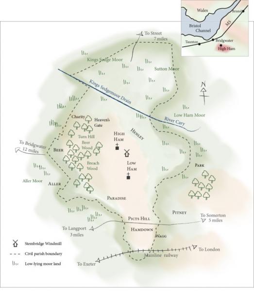
High Ham sits on what was originally an island rising out of the marshland. The hamlets of Beer, Henley, Low Ham and Paradise skirt the hill with Aller and Beer Woods flanking the western escarpment. At the southern end are Hamdown and Picts Hill, while Wagg skirts the south-east slopes.
High Ham was recorded in the Domesday Book 1086 as Hane, from the Old English meaning home and having 17 hides (approx. 1700 acres) and was part of the Whitley Hundred.
High Ham
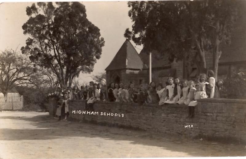
- The Old School House – an Elizabethan school built in 1598 by the rector Adrian Schael.
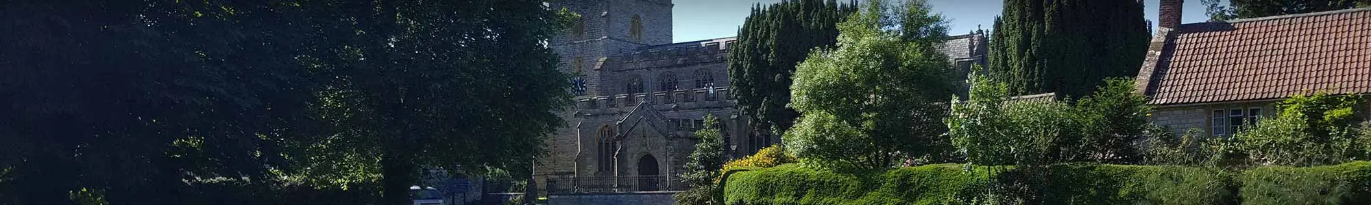
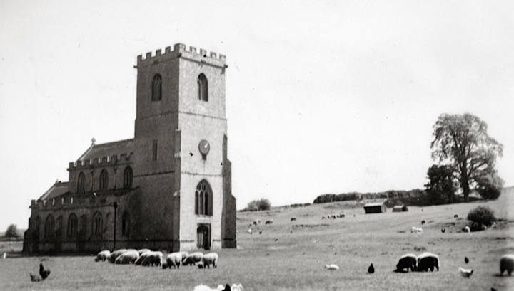
- St Andrew’s Church – originally a Norman church, but rebuilt in 1476. The tower was built within one year. It has a carved rood screen carved by the monks of Glastonbury Abbey, and a collection of grotesques or hunky punks.
- Manor Farm – dating back to the medieval times, it is a typical E shaped 16th century manor/farm house. The manorial court sessions were held here. It is still a working farm.
- The Old Rectory – built in in 1862, it was designed by the architect John Norton who also designed Tyntesfield.
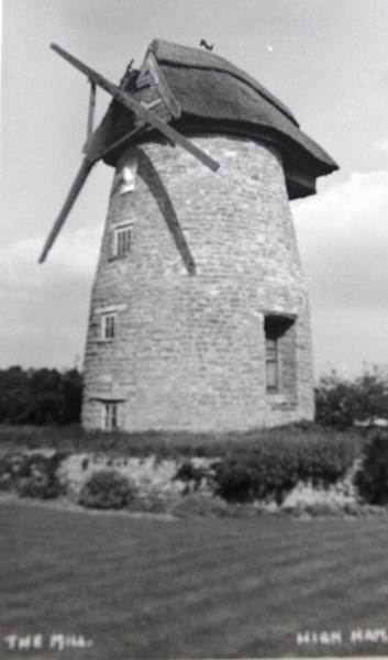
- Stembridge Windmill – it is the last remaining thatched windmill in England. It is the last of a series of mills in the area. The mill was given to the National Trust by Professor Bellot.
- The King’s Head – known to be a pub in the early 1800s. The Thyer family ran it for over 100 years until the 1900s.
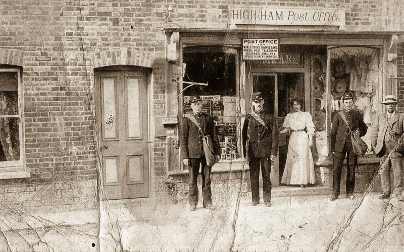
- Wheelwright’s Stone – outside Wheelwrights and opposite the church is the bonding stone where the wheelwrights secured iron rims to to cartwheels. A building was added in the early 20th century to house the post office and telegraph office, but is nolonger there.
- A Roman villa – sited near Sam’s Cross, it was excavated by Channel 4’s ‘Time Team’ in 2001.
Low Ham (formerly known as Netherham)
There is evidence of a settlement in Low Ham at least since Roman times.
- Low Ham Roman mosaic – in 1938 Mr Cook, a local farmer, was burying a dead sheep when he discovered a roman villa on his land. It was excavated in 1946. A narrative mosaic was found depicting the story of Dido and Aeneas. It can be seen at The Museum of Somerset, Taunton.
- The ‘Church in the Field’ – in the same area is a grade 1 listed church without dedication. It was to be a chapel for the manor, but was damaged in the Civil War and was not completed until 1690.
- The Stawells – Baron Stawell started to build a large mansion. Evidence of the large gardens can be seen, but it was never completed and fell into ruins when he went bankrupt.
- Later use of the area – in the 1920s and 1930s the fields in the south were a golf course. During WW2 Nissen huts were built at the top of Cook’s Hill and housed the soldiers that manned he searchlight at Ivy Corner. The huts are still there. The field now hosts the annual Somerset Steam and County Show.
- Properties dating from the 16th century or even earlier – Old Manor Farm was the courthouse and the Lord of the Manor’s house mentioned in Pevsner’s ‘The Buildings of England’, and is now a private residence. Dairy House Farm: a farm till the late 1990s and is now a private residence.
- Fir Tree Farm – formerly The Fleur-de-Lys. It was a coaching inn dating from the 17th century. Outside is a 3-step mounting block, a relic from stage-coaching days.
Henley
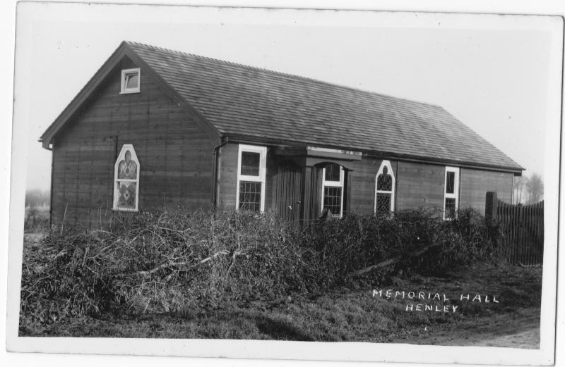
The hamlet skirts the base of High Ham escarpment facing Kings Sedgemoor. Its name means meadow land.
- The Kings Sedgemoor Drain (KSD) – before it was built, the area was a huge source of food and money eg. wildfowl, fish, eels, rushes, reeds, osiers and peat fuel. It was graded for taxes into marsh, moor, pasture and meadow. After much opposition for many years by the ‘lower order of commoners’, in 1794 work started on cutting a completely new channel from Henley Corner, where the River Cary enters the moor, to Dunball (River Parrett estuary) costing over £200,000.
- Road to Pedwell – in 1822 the road to Pedwell was built via Henley Corner. A more direct route via Cradle Bridge was made and turnpiked in 1826 by the High Ham and Ashcott Trust. Willows were planted as guide posts to safeguard travellers from the deep ditches either side.
- Houses to have survived from the late 16th/17th centuries – Henley Farm, Windsor Farm, Poplar Farm, Chapel Farm.
- In the 19th century – there was a dame school and two shops.
- Henley Chapel – a Non-Conformist chapel was built in the 1840s and is still thriving today.
Beer
Beer is on the west side of the escarpment. Most of the hamlet is within Aller parish.
- Beer Farm – built in the early 19th century, The house and adjacent barn are both listed. The barn has a tallet (a loft above a stable with a trap door in the ceiling accessed from below, or an external stairway).
- Charity Farm – built in the early 19th century, it is still a working dairy farm. The bridge near the farm was one of the only three access points on to the moor prior to the Kings Sedgemoor Drain (Henley Corner Bridge and Pitney Steart the other two).
Paradise

The name first occurs in 1562.
- A water mill – used for grinding corn. in 1804 it was sold to William Hill of High Ham then passed to the Spearing family, who also milled at Stembridge and Isle Brewers. It ceased working in the 1930s.
- Firing Range – little is known about the Langport Rifle Range in Paradise Valley. It is thought to date back to the 1600s. Somerton Royalist troops trained here in both world wars. The range and Breach Wood are still used by the MoD.
Picts or Picks Hill
- High Ham to Ascott Road – in 1826 it began at Picts Hill and went to Meare via High Ham and Ashcott. It was a turnpike road which ceased in 1879.
- Wearne Wych – a Gothic Revival house, was built in 1875 by G. Nattress for Mr Paul, a director of Stuckey’s Bank.
- The 1920s – Picts Hill had a haulier, laundry and bicycle shop.
Hamdown and Union Drove
- The Civil War – the Battle of Langport was fought over Ham Down under the command of Lord Gore. They were swiftly outmanoeuvred by Sir Thomas Fairfax, the Parliamentarian Richard Thomas, a Welsh soldier, was found in a ditch mortally wounded. He is buried at High Ham.
- The Langport Union Workhouse – sited on what is now Hamdown Court, a residential area, it was built in 1837 and High Ham Parish became part of the Langport Poor Law Union. It was based on the design of Dampson Kempthorne’s hexagonal plan. It closed in the 1930s. During WW2 it was used as a US military detention centre. After the war it was a poultry farm and egg packing centre. It became derelict, and in 2004 it was demolished, redeveloped and renamed Hamdown Court.


Langport Union Workhouse – photos taken September 1996 (Gill Cracknell)
Wagg
- The hamlet of Wagg – it came about from encroachments by cottagers on Wagg Common during the late 17th and 18th century. Wagg Common and Ham Drove were enclosed in the late 18th century.
- A family school – held in the winter evenings in the 1850s.
-
Main railway line to London – in 1906 the mainline to London was built. A low bridge straddles the road as it bisects the hamlet.
World War 1 – British Legion Booklet listing the men of HH Parish who enlisted to fight in WW1. Photos, newspaper reports etc. Compiled by Philippa Brett.
Stories of the men from High Ham Parish who died in WW1 service Links to websites of Parish history interest
2012 Jubilee Scrapbook: a celebration of village life by residents of High Ham, Low Ham, Henley, Beer and Hamdown
High Ham Parish History Project – more about the history of the parish and the project
Sarah Hawkins Genealogy Site High Ham: a list of all the records she found for the parish of High Ham, Somerset Caroline Cox (neé Richards) – her singing of folk song O Waly Waly collected by Cecil Sharp 1905